-
9-1) 일사량, 음영, 그리고 가장 중요한 '계통 연계(선로)' 용량 확인법손 가는 대로/태양광 2026. 8. 10. 08:19728x90
태양광 투자 A to Z
제9장. 수익률을 결정짓는 '입지' 선정 노하우
1. 일사량, 음영, 그리고 가장 중요한 '계통 연계(선로)' 용량 확인법
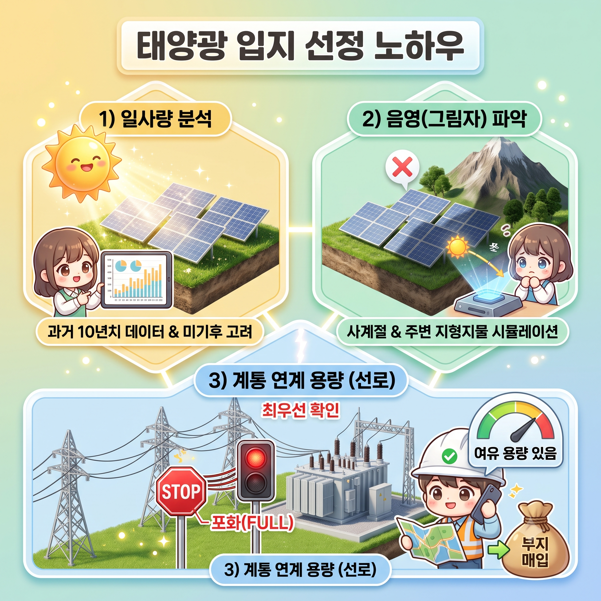
부동산 투자에서 첫째도 입지, 둘째도 입지라는 말이 있듯, 태양광 발전 사업에서도 부지 선정은 전체 프로젝트의 성패를 가르는 가장 결정적인 단계입니다. 땅값이 저렴하다고 해서 무턱대고 부지를 매입했다가는 예상치 못한 암초에 부딪혀 막대한 손실을 볼 수 있습니다. 태양광 발전소의 수익률을 극대화하기 위해 입지 선정 시 반드시 확인해야 할 세 가지 핵심 요소인 일사량, 음영, 그리고 계통 연계 용량에 대해 자세히 알아보겠습니다.
태양광 발전의 핵심 연료, 일사량 분석
태양광 발전소에서 태양빛은 곧 화력 발전소의 석탄이나 가스와 같은 '무상 연료'입니다. 따라서 부지에 얼마나 많은 햇빛이 쏟아지는지 파악하는 것이 수익성 분석의 출발점입니다.
일사량을 확인할 때는 단순히 그 지역이 남부 지방인지 중부 지방인지 감으로 판단해서는 안 됩니다. 한국의 경우, 기상청 데이터나 한국에너지기술연구원의 신재생에너지 데이터센터 등을 활용하여 해당 지번의 과거 10년 치 이상의 일사량 및 일조시간 데이터를 확인해야 합니다. 연평균 일사량이 하루 3.5시간 이상 확보되는 곳이 경제성이 높다고 평가받습니다.
또한, 거시적인 데이터뿐만 아니라 해당 지역의 미기후(Microclimate) 특성도 반드시 고려해야 합니다. 예를 들어, 남부 해안가에 위치하여 일사량 데이터는 우수하게 나오지만, 실제로는 바다 안개가 자주 끼거나 분지 지형이라 아침저녁으로 습기가 오래 머무는 곳이 있습니다. 이런 곳은 실제 발전 시간이 크게 줄어들 수 있으므로, 반드시 여러 차례 현장을 방문하여 지역 주민들에게 실제 날씨 특성을 탐문하는 과정이 필요합니다.
수익률을 갉아먹는 숨은 적, 음영(그림자) 파악
일사량이 아무리 풍부하더라도 발전소 패널 위로 그림자가 진다면 발전량은 급감합니다. 태양광 모듈은 여러 개의 셀이 직렬로 연결되어 있기 때문에, 패널의 작은 일부분에만 그림자가 져도 전체 발전 효율이 뚝 떨어지는 특성이 있습니다.
음영을 분석할 때는 계절별 태양의 고도 변화를 반드시 계산해야 합니다. 여름철에는 태양의 고도가 높아 주변 산이나 건물의 그림자가 짧게 지지만, 겨울철에는 태양 고도가 낮아져 그림자가 훨씬 길어집니다.
구체적인 예시를 들어보겠습니다. 남향으로 탁 트인 저렴한 밭을 발견하고 부지를 매입한 투자자가 있습니다. 여름에 현장을 방문했을 때는 주변에 그림자를 만들 만한 요소가 없어 보였습니다. 하지만 막상 발전소를 짓고 첫 겨울을 맞이하자, 부지 남서쪽에 위치한 야산의 그림자가 오후 3시만 넘으면 발전소를 덮쳐버렸습니다. 겨울철 오후의 발전량을 고스란히 날리게 된 것입니다.
이러한 낭패를 피하기 위해서는 부지 주변의 지형지물, 송전탑, 인접한 건물은 물론, 앞으로 자라날 나무의 높이까지 고려하여 3D 음영 시뮬레이션을 돌려보아야 합니다. 특히 부지 남쪽과 동서 방향에 장애물이 없는지 꼼꼼히 확인하는 것이 중요합니다.
모든 것을 무용지물로 만드는 장벽, 계통 연계(선로) 용량 확인
부지의 일사량이 뛰어나고 음영도 전혀 없는 완벽한 땅을 찾았다고 가정해 보겠습니다. 당장이라도 땅을 사고 싶겠지만, 가장 마지막이자 가장 중요한 확인 절차가 남아 있습니다. 바로 한국전력의 전력망에 내 발전소를 연결할 수 있는지, 즉 '계통 연계 여유 용량'을 확인하는 일입니다.
아무리 전기를 많이 생산해도 한전 선로를 통해 판매하지 못하면 그 전기는 버려집니다. 최근 전라도, 경상도 등 일사량이 좋은 남부 지역은 이미 기존에 설치된 태양광 발전소들로 인해 한전의 변전소와 배전 선로 용량이 꽉 찬 곳이 대다수입니다.
선로 용량을 확인하려면 한전에서 제공하는 '분산전원 연계정보 포털'에 접속하여 해당 지번 주변의 전주 번호를 입력하거나 지도를 검색해 보아야 합니다. 이곳에서 인근 변전소 및 배전 선로의 누적 연계 용량과 잔여 용량을 실시간으로 파악할 수 있습니다.
예를 들어, 선로 용량 확인 없이 땅부터 덜컥 매입한 투자자가 있다고 해보겠습니다. 지자체의 개발행위허가까지 힘겹게 받았지만, 한전에 계통 연계를 신청하자 "해당 지역 선로 용량이 포화 상태라, 5년 뒤 신규 변전소가 건립되어야만 연결이 가능합니다"라는 답변을 받게 됩니다. 결국 이 투자자는 5년 동안 전기를 팔지 못하고 대출 이자만 내야 하는 최악의 상황에 처하게 됩니다.
따라서 입지를 선정할 때는 일사량이나 땅값보다 '한전 선로 용량이 남아 있는지'를 최우선으로 확인해야 합니다. 만약 여유 용량이 부족하다면, 아무리 조건이 좋은 땅이라도 미련 없이 돌아서는 것이 현명한 투자자의 자세입니다.
---
Solar Investment A to Z
Chapter 9. Know-how on Selecting the "Location" that Determines the Rate of Return
1. Checking Irradiance, Shading, and the Deal-Breaker: Grid Interconnection Capacity
In the world of real estate, the golden rule is "location, location, location." This mantra holds just as true for solar energy investments, but the definition of a prime location goes far beyond highway access or neighborhood demographics. Acquiring cheap land is meaningless if it fails the fundamental tests of a power-generating asset. To ensure a profitable and bankable solar project, investors must rigorously evaluate three foundational pillars during the site origination phase: solar resource, topographic shading, and grid hosting capacity. Let us delve into how to assess these critical elements.
Evaluating the Solar Fuel: Irradiance and Microclimates
Sunlight is the free fuel that powers your solar facility. Therefore, accurately estimating the available solar resource is the starting point of any financial model.
When assessing irradiance, you cannot rely on broad regional assumptions. Investors must utilize specialized satellite and meteorological databases, such as NREL's PVWatts in the United States or global platforms like Solargis. These tools provide historical data on Global Horizontal Irradiance (GHI) and Direct Normal Irradiance (DNI) for exact GPS coordinates. A viable utility-scale project typically requires a solid baseline of annual irradiance to guarantee economic returns.
However, macro-level data often misses the nuances of a site's microclimate. Consider an investor looking at a coastal property in California. The satellite data for the general region might indicate excellent average sunlight. Yet, local geographic features might cause thick marine layer fog to settle over that specific parcel every morning until noon during the summer months. This localized weather pattern drastically reduces the actual production hours. Thorough due diligence requires crossing satellite data with local meteorological reports and on-the-ground observations to account for these localized weather anomalies.
Identifying the Hidden Enemy: Shading and Topography
Even with abundant irradiance, your energy yield will plummet if shadows fall across your arrays. Because standard solar panels are connected in series strings, shading even a small portion of a single panel can disproportionately restrict the current and reduce the power output of the entire connected string.
When evaluating shading, investors must look beyond the immediate obstacles and consider the "solar window" across different seasons. The sun's trajectory changes significantly throughout the year. While a nearby hill might not cast a shadow during the high sun of summer, the low angle of the winter sun can stretch that shadow dramatically.
For example, imagine a developer purchasing a seemingly perfect, flat valley parcel. During a site visit in June, the horizon appears clear. However, once the plant is operational, they discover that a mountain ridge to the southwest completely eclipses the sun by 2:30 PM from November through February. The project loses a massive chunk of its projected winter revenue. To avoid this, investors must use sophisticated 3D modeling software (like PVSyst) equipped with topographical horizon data to simulate shading minute-by-minute, 365 days a year, accounting for nearby terrain, existing structures, and even the future growth of nearby vegetation.
The Ultimate Deal-Breaker: Grid Interconnection Capacity
Let us assume you have found the Holy Grail of solar sites: brilliant irradiance, perfectly flat terrain, zero shading, and willing landowners. It might seem ready for investment, but there is one final, ruthless hurdle. You must determine if the local utility grid has the physical capacity to absorb and transport the power you intend to generate. This is known as grid hosting capacity or interconnection headroom.
Generating electricity is futile if you cannot deliver it to the market. In many established solar markets globally, from Texas and Spain to South Australia, the transmission infrastructure has not kept pace with the boom in renewable energy development. As a result, many substations and power lines are completely saturated.
Investors must consult the local grid operator's hosting capacity maps or submit a preliminary interconnection inquiry before finalizing land leases. Take, for instance, a developer who signs a lease for a 50-megawatt site without checking grid availability. They spend hundreds of thousands of dollars on environmental permits, only to be informed by the utility that the local substation is full. The utility states that connecting the new project will require a 20-million-dollar transmission upgrade that will take six years to build. The project economics instantly collapse, and the development capital is lost.
Therefore, confirming grid interconnection capacity must be the absolute first step in site selection. If there is no available capacity on the nearby lines, or if the upgrade costs are prohibitive, the smartest move an investor can make is to walk away, no matter how attractive the land may appear. Finding the precise intersection of good sun, clear horizons, and open grid capacity is the true art of solar origination.
 728x90
'손 가는 대로 > 태양광' 카테고리의 다른 글
전력 산업과 주요 용어 (0) 2026.08.10 태양광 발전 사업에서 주요 검사 (0) 2026.08.07 지중(地中)과 가공(架空) (0) 2026.08.07 8-3) 매물 검색부터 현장 실사(DD), 계약까지의 필수 체크리스트 (0) 2026.08.07 태양광 출력제어 (Curtailment) (0) 2026.08.06